Unseasonably hot weather for PJM early-mid this week, but especially on Monday 4/29 and Tuesday 4/30. The charts below highlight the minimum and maximum temperatures for Washington DC on Monday and Tuesday. Note that on Monday 4/29 the KDCA min temperature of 65F is in the 95th percentile and the max temperature of 91F is in the 98th percentile.
On Tuesday 4/30 the KDCA min temperature of 67F is in the 100th percentile and the max temperature of 91F is also in the 100th percentile. The max of 91F would break the previous record for that day which was 88F set back in 2017.
The PJM max aggregate temperature for Monday 4/29 is 84F (30-year normal is 70F) and PJM min aggregate temperature for Monday 4/29 is 62F (30-year normal is 49F). Monday is the hottest day across the ISO. By Tuesday 4/30, eastern PJM will remain unseasonably hot but western PJM will have increasing rain risk which could crush daytime highs.
The temperature forecast change chart below shows no major changes for Monday 4/29, but shows cooler temperatures across western PJM on Tuesday 4/30 due to rain and cloud cover. Wednesday 5/1 was generally cooler across most of the ISO while Thursday 5/2 through Sunday 5/5 was warmer by 3-6 degrees across PJM. The 11-15 day period changes for the first full week of May (5/6-5/10) were mostly to the cooler side by 2-4 degrees day-on-day.
The probability of precipitation chart below shows rain risk for western PJM on Monday 4/29 followed by widespread rain risk across PJM ISO on Tuesday 4/30. HOWEVER, the risk for precipitation in Eastern PJM will likely not come to fruition until after the peak afternoon hours of Tuesday. We will be closely monitoring the intraday situation, though, for PJM on Tuesday watching for any signs of slightly faster frontal progression.
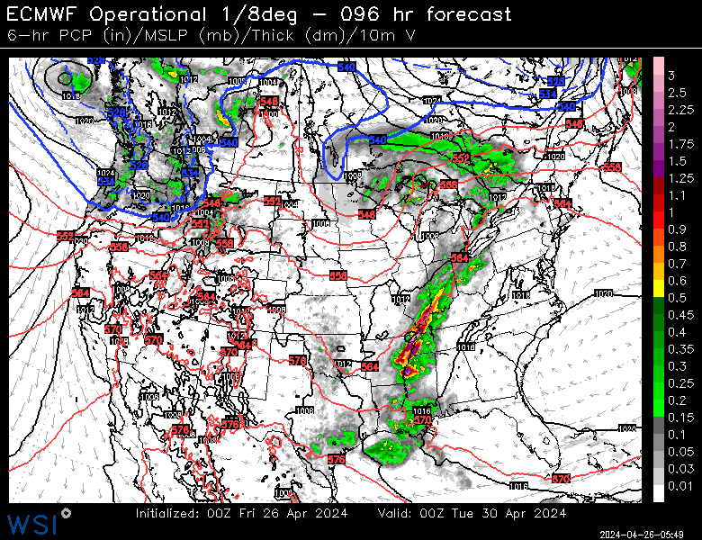
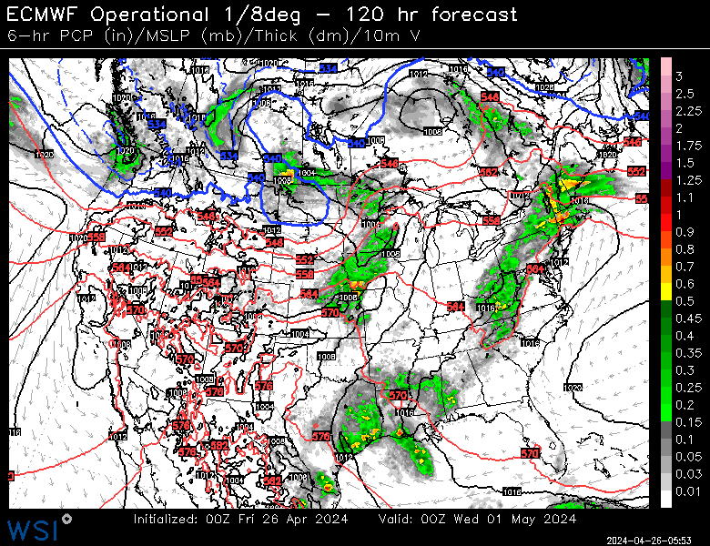
The latest ECMWF operational weather model precipitation forecast for Monday 4/29 and Tuesday 4/30 afternoon hours is shown below. Note the progression of the frontal boundary and precipitation line across PJM during early next week. There would likely be a large temperature spread between East (hotter) and West (cooler) PJM on those days.
Our latest internal PJM hourly wind generation forecast reveals high wind generation (40-60% capacity range) on Monday 4/29 followed by low-moderate wind generation on Tuesday 4/30 and Wednesday 5/1.
Our latest internal PJM peak hourly power load forecast reveals 106,761 MW on Monday 4/29, 93,400 MW on Tuesday 4/30, 95,711 MW on Wednesday 5/1, 96,545 MW on Thursday 5/2 and 93,134 MW on Friday 5/3.
Some forecasts are harder than others, and our Forecast Risk Index (FRisk) tool allows busy users a means of quickly identifying where 1-15 day weather forecasts are more likely (or not) to go bad, via a red-light, green-light paradigm from the AG2 Trader home page.
Low FRisk may mean weather is already correctly “baked in” to market prices, while high FRisk may suggest potential price volatility and market opportunity.
FRisk provides a direct path to a deeper dive into the full 15-day probabilistic distribution, via one click from the home page, where users can easily discern directional risk. As a meteorologist growing up on a trade floor, I wish that I had access to this product years ago! While I use this tool everyday, it’s output is especially helpful on a Friday when assessing what could “go wrong” forecast-wise walking into Monday morning’s forecast.
Note the large area of higher than normal FRisk values across the mid-continent on Thursday 5/2 through Saturday 5/4. The reason for the higher than normal risk during that period across the mid-continent is likely due to big model disparities associated with timing of a frontal system.
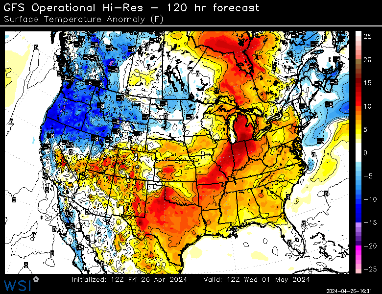
The images below are from the latest 12z GFS operational hi-resolution imagery for Wednesday morning, May 1st and Friday morning, May 3rd. Note the evolution of the massive cold front pushing from the Northwestern USA across the mid-continent while the Eastern USA warms to above and even much above normal temperature levels. Timing and placement of this front is obviously very crucial to the USA weather pattern during the balance of next week. For example, a faster and stronger cold front could translate to even hotter temperatures across the South and East early-mid next week, followed by cooler weather late in the week.
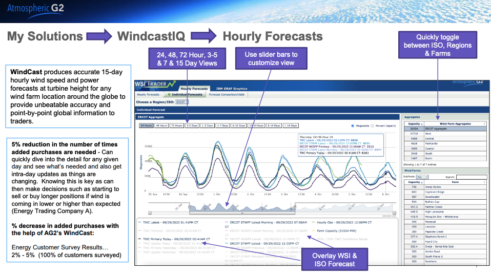
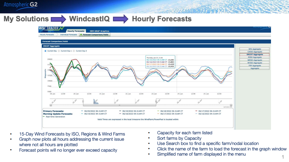
Did you know we offer ISO/RTO and farm level wind forecasts for North America? This blog takes a look at the solution as a whole along with some realtime applications.
WindCast IQ is available for the following regions as well as at the farm level in these regions.
WindCast IQ is housed within the AG2 Trader platform and provides hourly wind speed and power forecasts at turbine height. Users can compare our internal forecast with the ISO, regional and farm level forecasts easily as well.
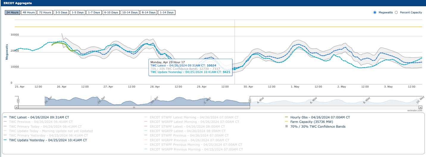
Another great tool customers can utilize is our 30-70% probabilistic confidence bands. By harnessing our suite of probabilistic data, we can identify up/downside risk easily by showing this range of possible solutions – Monday 4/29 in ERCOT is a great example as wind ramps up during the all important evening hours:
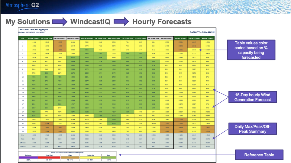
We also provide color coded hourly forecasts based on percentage of capacity being forecasted which shows hourly generation as well as daily max/peak/off peak summaries.
Users can also quickly view aggregate forecast performance against current observations, too, going back 3 days.
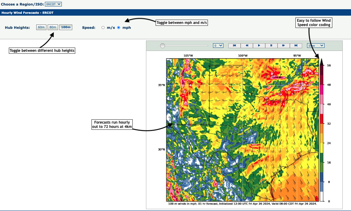
Finally, customers have access to the high resolution GRAF model, which is run at 4km and runs hourly to 72 hours. Users can toggle between 60, 80, and 100m heights.
Windcast IQ is a powerful tool that many AG2 customers utilize – if you would like more info on this product, please reach out to sales@atmosphericg2.com!
This blog takes an updated look at the last few months of precipitation, the next 2 weeks of precipitation risk, and a longer term water supply forecast.
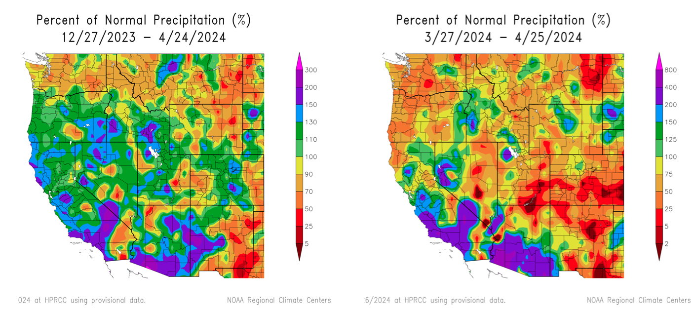
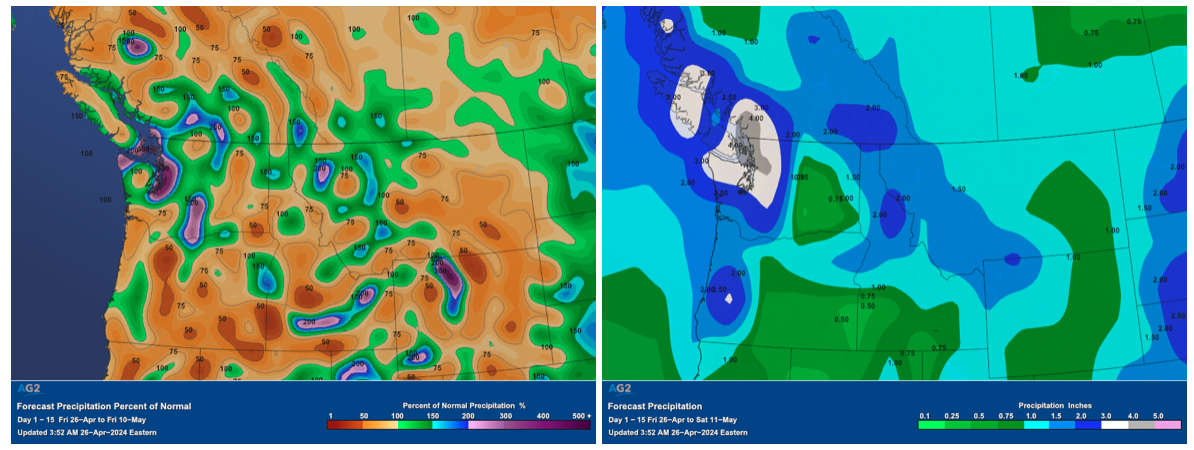
Looking at the precipitation data over the last 30 days and the last 120 days, we can see above normal precipitation for most of Oregon and southern Idaho over the longer term period (left) but the last 30 days have been rather dry everywhere in the PNW…
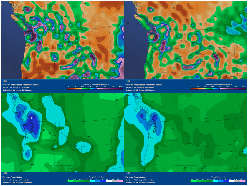
Looking at the precipitation forecast into the front half of May, it does look like there will be better precipitation opportunities both in week 1 and week 2. Both weeks are shown below along with 1-15 day below that.
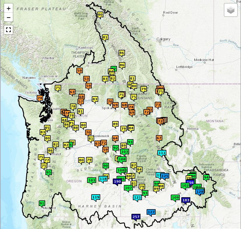
Looking at the water supply forecast for April-September shows generally 70-85% of normal for the Columbia River basin, and 90-130% for the Snake River basin where rains have been more widespread and heavier.
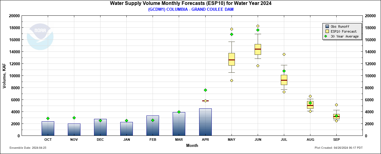
We can see water supply volume forecast at centrally located Grand Coulee Dam looks to run below average through the middle of the summer.
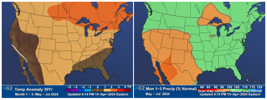
Looking ahead to our May-July outlook, we do see some precipitation returning to the PNW as El Nino weakens. At the same time, slightly above normal temperatures are also favored.
We expect much hotter than normal weather across PJM during the balance of next week, with the hottest day outright being Monday 4/29 with a PJM aggregate overnight low of 62F (30-yr normal is 49F) and a PJM aggregate daytime high of 84F (30-yr normal is 70F). Places like Washington DC are forecast to hit a high of 91F on Monday 4/29 and 90F on Tuesday 4/30 which is typically normal during mid July! Our latest 15-day min/max temperature forecast is shown below.
The chart below shows the 30-year anomalies for PJM and each city within the ISO. Note that temperature anomalies will reach up to 15-20 degrees hotter than normal on both overnight lows as well as daytime highs, especially during next Monday 4/29 and Tuesday 4/30.
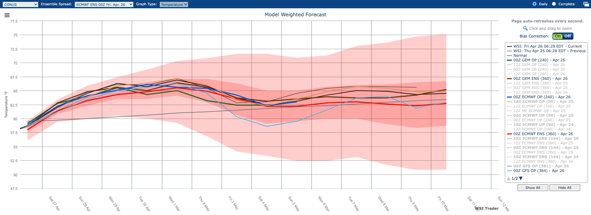
Our new AG2 Trader weather platform features this neat pop-up chart when you hover over and click on individual cities within the 15-day forecast. Let’s check out Washington DC as a real-world example below. We currently have an overnight minimum temperature of 65F in Washington DC forecast for next Monday 4/29 which is very rare (in the 100th percentile). Clients have the ability to hover over the scatter plot and that would reveal a temperature equal to or warmer than our forecast of 65F has only occurred three other times dating back to 1960 (2021, 2017 and 1962).
We currently have a daytime maximum temperature of 91F in Washington DC forecast for next Monday 4/29 which is also very rare (in the 100th percentile). Once again, hover over the scatter plot and that would reveal a temperature equal to or warmer than our forecast of 91F has only occurred one other time dating back to 1960 (2017).
Day on day forecast changes are warmer across PJM during the balance of next week while the 11-15 day period is much cooler compared to yesterday’s forecast as shown in the chart below.
Probability of precipitation is fairly low across PJM during most of next week, but Tuesday has the best chance of precipitation according to our forecast chart below.
The latest 00z run of the ECMWF operational model for next Monday 4/29 afternoon shows the frontal system over western PJM slammed with rain while eastern PJM will have south-southeasterly flow and hot/humid weather.
By next Tuesday 4/30, however, note the frontal system and line of precipitation is getting very close to major population centers in eastern PJM hence our increase in probability of precipitation for next Tuesday.
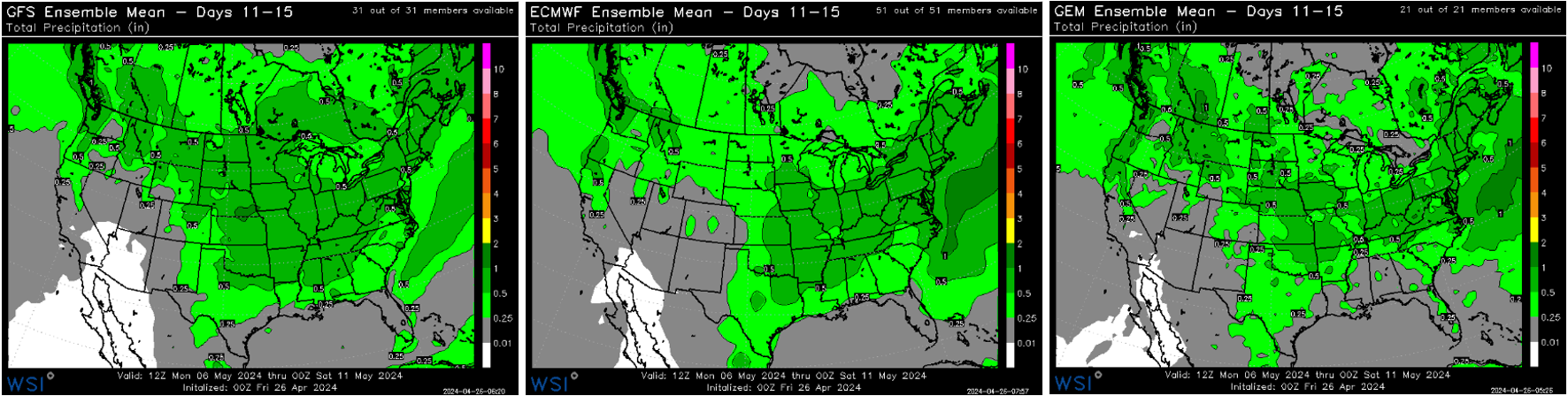
The chart below shows the total daily forecast amounts of precipitation in inches for each PJM location.
Peak hourly PJM power load forecast shows Monday 4/29 hitting a peak of 104,581 MW followed by 93,822 MW on Tuesday 4/30 and 98,869 MW on Wednesday 5/1.
PJM wind generation is forecast to be at high levels on Monday 4/29 between 5-7 GW followed by lower levels on Tuesday 4/30 between 1-5 GW and Wednesday 5/1 between 1-3 GW.
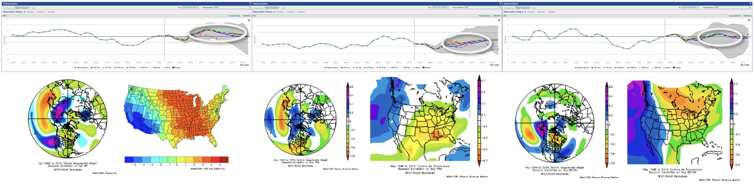
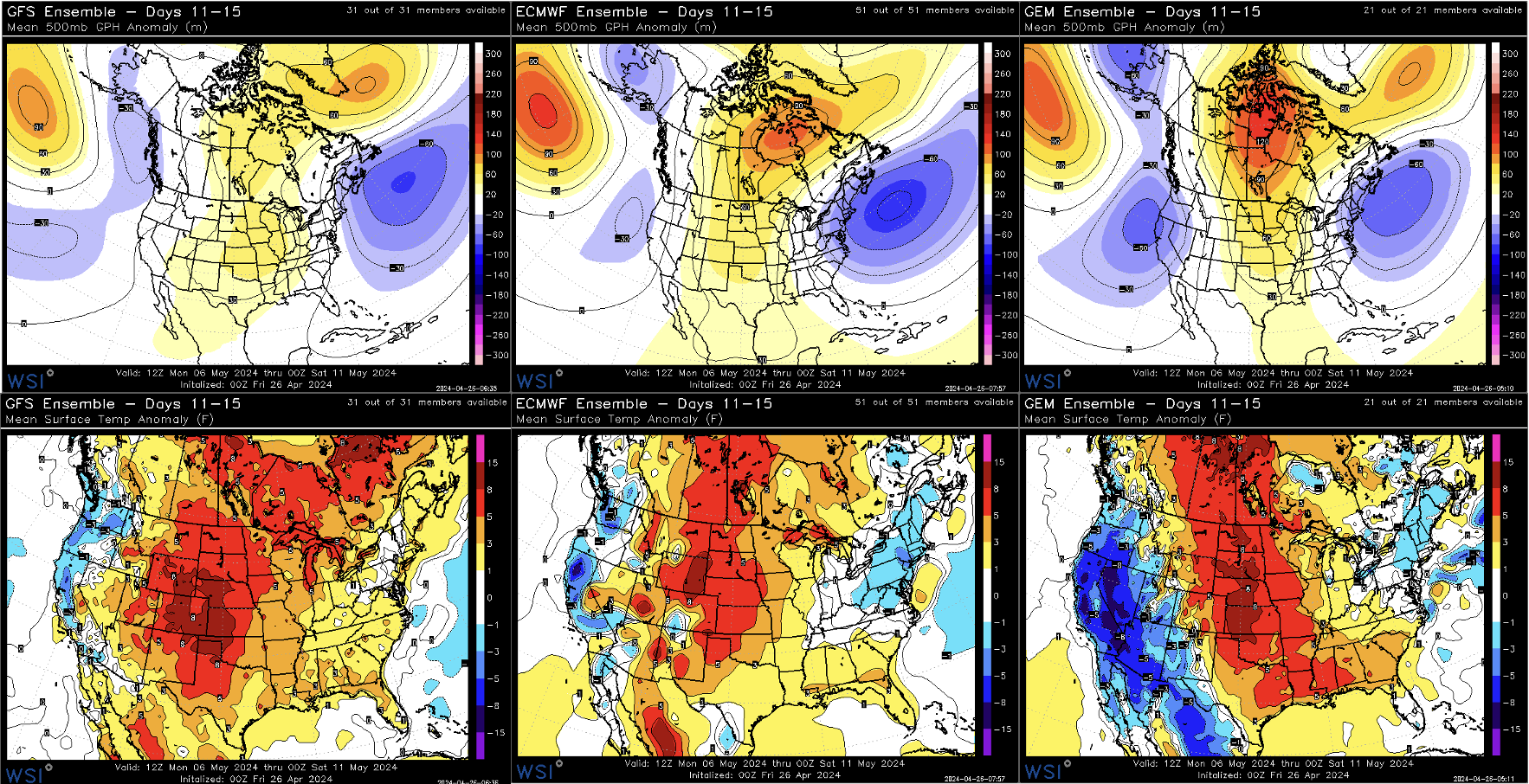
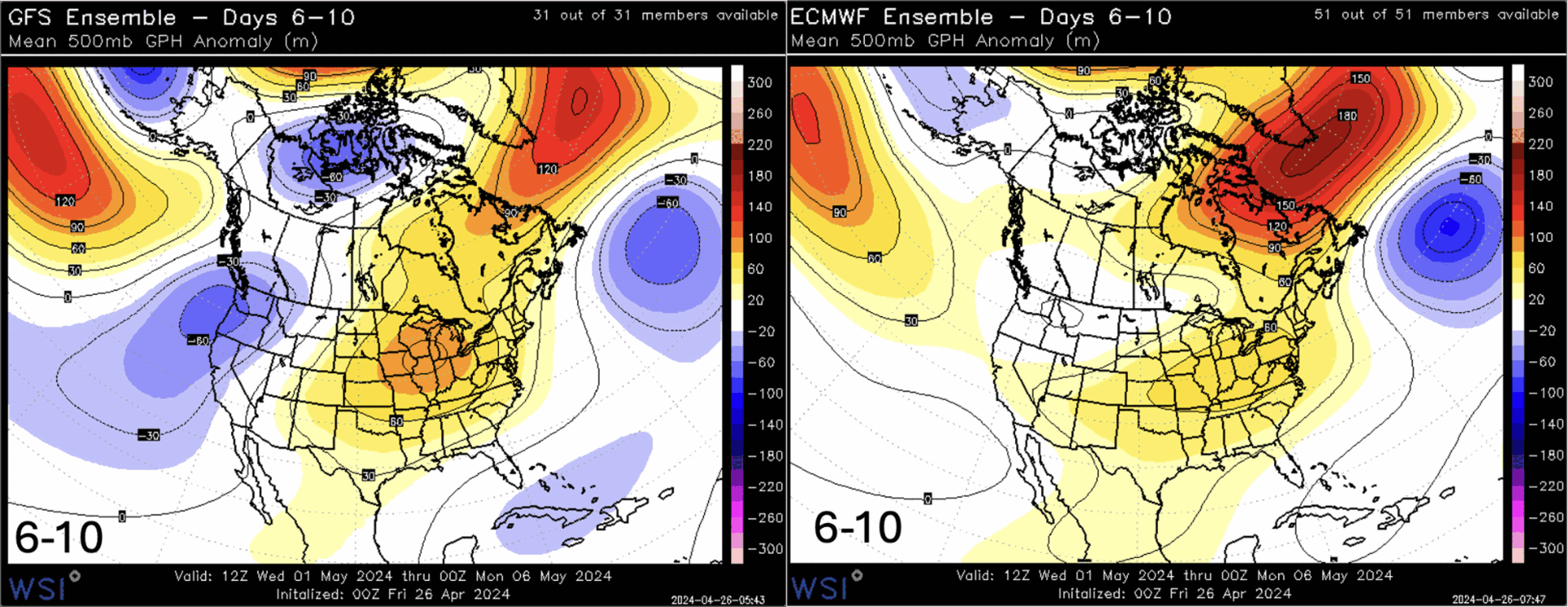
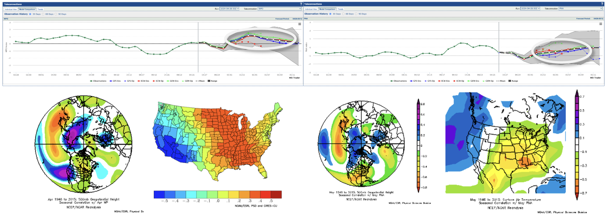
Overview: The -PNA/+WPO regime will continue early in the 11-15 day period, with a slight evolution toward a more broad +EPO pattern as the period progresses. Notably, the +EPO still shares similarities with the -PNA and the +WPO in that all three are correlated with above-average temperatures across the central and eastern US, while the West is more prone to mid-level troughing and seasonably cool, unsettled weather.
The main difference between the two regimes here will be the placement of the trough axis in the West. A +EPO pattern will result in a western trough that digs just a bit farther west compared to the one in the 6-10 day period, which would allow for more resilient ridging in the Mid-Con. This means that we will likely see a continuation of the warmth across the Plains and Midwest, while portions of the Northeast will see greater chances of cold frontal passages and cooler temperatures.
Notably, ensemble guidance deviates a bit during the latter half of the period. The GEFS suggests a mere continuation of the pattern established toward the end of the 6-10 day period, while the EPS continues to shift the main ridge axis further west, suppressing severe weather chances and introducing cooler temperatures to the eastern United States.
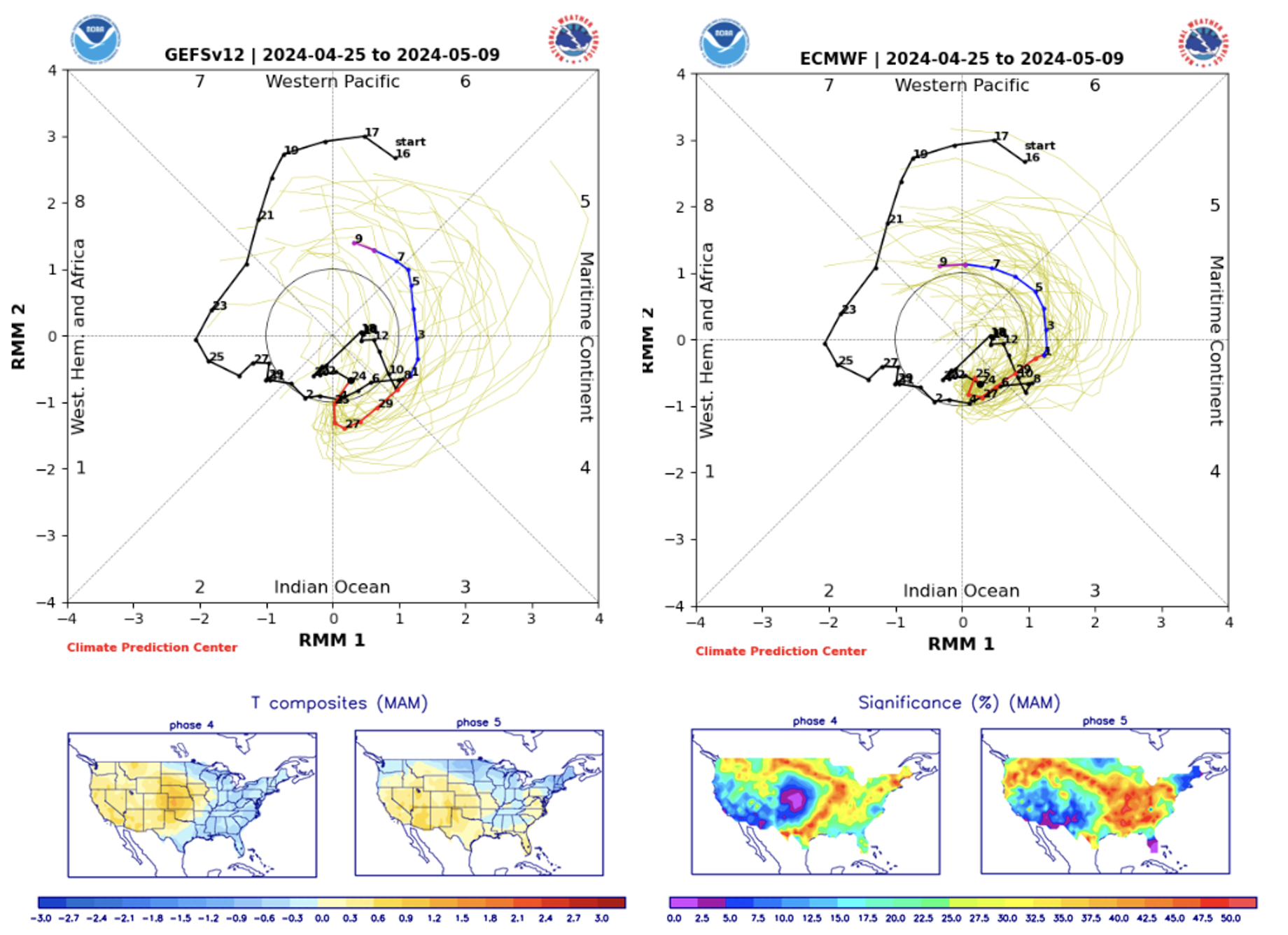
If we take a look at tropical forcing we see a strengthening MJO signal propagating into phase 6 during the 11-15 day period, which typically corresponds to warmth across the eastern two thirds. This would give some support to the GEFS solution calling for the ridge axis to remain established across the Midwest rather than over the Plains. However, backdoor cold fronts and cold onshore flow for portions of the Northeast would still be a concern and would drive significant regional temperature differences
Forecast Details: The details are a little murky around the beginning of the 11-15 day period. The active pattern is expected to ease a bit with the expansion of the Mid-Con ridge. However, a few more shortwaves are still likely to move across the Rockies, potentially resulting in a dynamic low-pressure system traversing the central US. This means severe weather chances will remain across portions of the Mid-Con through early May, with the timing of convection playing a critical role in hourly load levels.
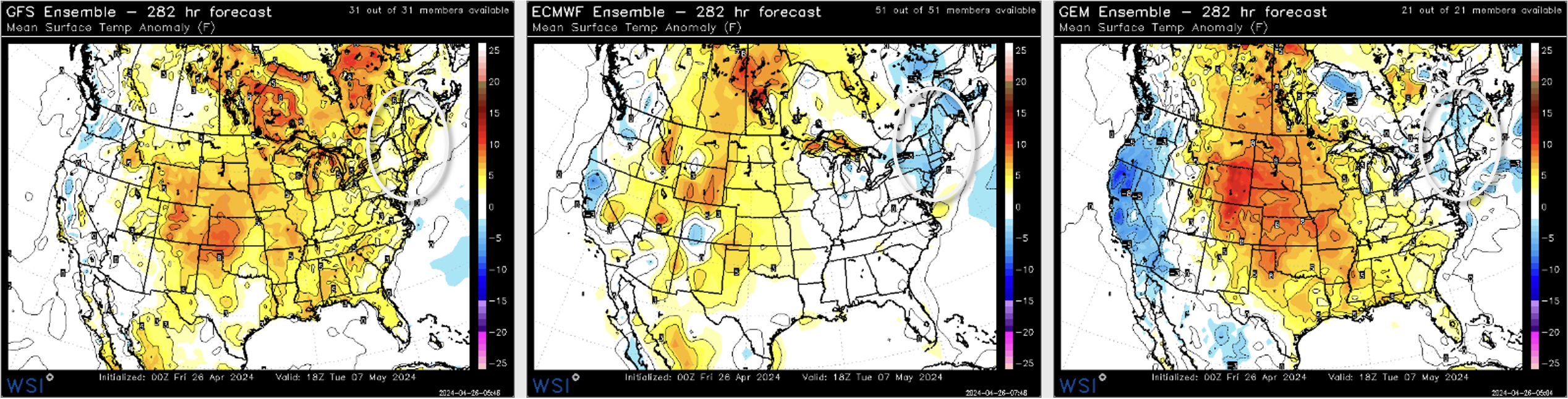
The expansive ridge across the central and eastern US, along with southerly flow ahead of potential systems, will continue to elevate heat and humidity—especially in the Central Plains and Southeast, where models consistently predict above-normal temperatures through day 15. The eastern US will likely see occasional shower and thunderstorm activity associated with weakening frontal systems, with portions of the Northeast subject to cold, onshore flow from the Atlantic. This will likely moderate temperatures across parts of New England and the Upper I-95 Corridor, with backdoor cold fronts leading to locally cloudy and cool conditions, while areas further inland break into full springtime warmth.
As for the western US, the pattern is relatively straightforward. The western-based trough will result in continued incursions of energy from the Pacific, maintaining a cold and damp weather pattern here. Notably, the Northwest and Northern Rockies will continue to bear the brunt of the precip, while southern areas remain mostly dry and seasonable with occasional shower chances.
Degree Day and Model Weighted Forecast Overview:
The -PNA/+EPO pattern will lead to continued warmth across the central and eastern US, reducing the late-season HDDs below the seasonal average. However, CDDs are expected to see a slight increase, with above average heat and humidity across the Plains and Southeast, elevating early-season CDDs slightly above normal. There is a general cooler risk, favoring the Northeast and Northwest, based on the latest ensemble guidance and the pattern retrogression.
GWHDDs: The period average GWHDD value is down to 31. The GFS op has 28.5, the GFS ensemble has 16.9, the ECMWF ensemble has 27.6, and the GEM ensemble has 22.8. The AG2 morning forecast is for 21.4.
PWCDDs: The period average PWCDD value is only up to 15. The GFS op has 13.6, the GFS ensemble has 16.7, the ECMWF ensemble has 12.9, and the GEM ensemble has 17.6. The AG2 morning forecast is for 17.8.
Posted inNorth America Medium Range, North America Short Range|Comments Off on US: 11-15 Day… Pattern Retrogression Facilitates Cooler Conditions for the Northeast While Anomalous Warmth Continues for Most
Overview: Above normal springtime warmth is set to spread across the central and eastern US, accompanied by continued severe weather chances for the Plains and portions of the Midwest. The prevailing upstream Pacific pattern features a fluctuating upper-level ridge over the North-Central Pacific, anchoring the main upper-level trough axis across western North America. As a result, the central and eastern US will find themselves on the eastern side of this axis, where widespread ridging is expected to dominate. These are the typical characteristics of a springtime -PNA, which will likely characterize the pattern across the lower 48 over the next 10 days. Additionally, the pattern shares similarities with the +WPO, which remains firmly positive through the first week of May and also has correlations to above average temperatures across the eastern two thirds.
As the period progresses a slight retrogression will commence with the mid-level features across North America. Several storm systems moving into the West will help pump mild, subtropical air into portions of the central US, allowing the subtropical ridge to flex northward across the Mid-Con, shifting the main ridge axis away from the East Coast. This will set up a brief omegablocking pattern with a potent ridge across the Mid-Con flanked by general troughing along the East and West Coasts.
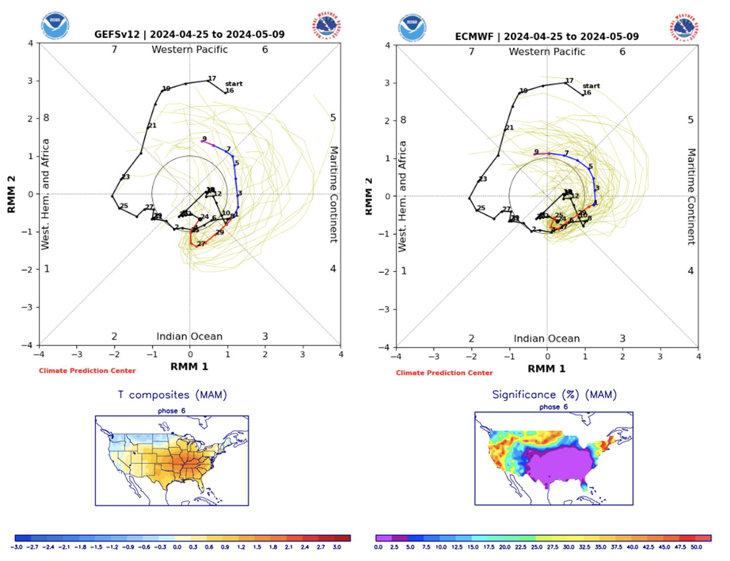
The cause of this retrogression is a bit unclear, but could be a product of the awakened and strengthening MJO signal. The MJO has been incoherent and unorganized for weeks, lacking significant influence on the tropics. However, models are indicating a more organized convective envelope progressing into phases 4 and 5 in the 6-10 day period. Notably, the MJO doesn’t have strong statistical significance in either phase for temperatures across the lower 48, but these phases are typically “colder” signals for the eastern US, particularly the Northeast.
Forecast Details: Several pieces of energy from the Pacific will look to move onshore into the western US over the next 10 days, leading to a cool and unsettled pattern in the region. Notably, the Northwest and the Northern Rockies will look to bear the brunt of the precip, with the rest of the region remaining mostly dry and seasonable. Multiple episodes of rain, showers, and mountain snow are expected to contribute to the replenishment of some mountain snowpack and reservoir levels in the area. Additionally, this increased precipitation will support elevated hydroelectric generation in the Northwest, offsetting some of the decreased solar output in the region.
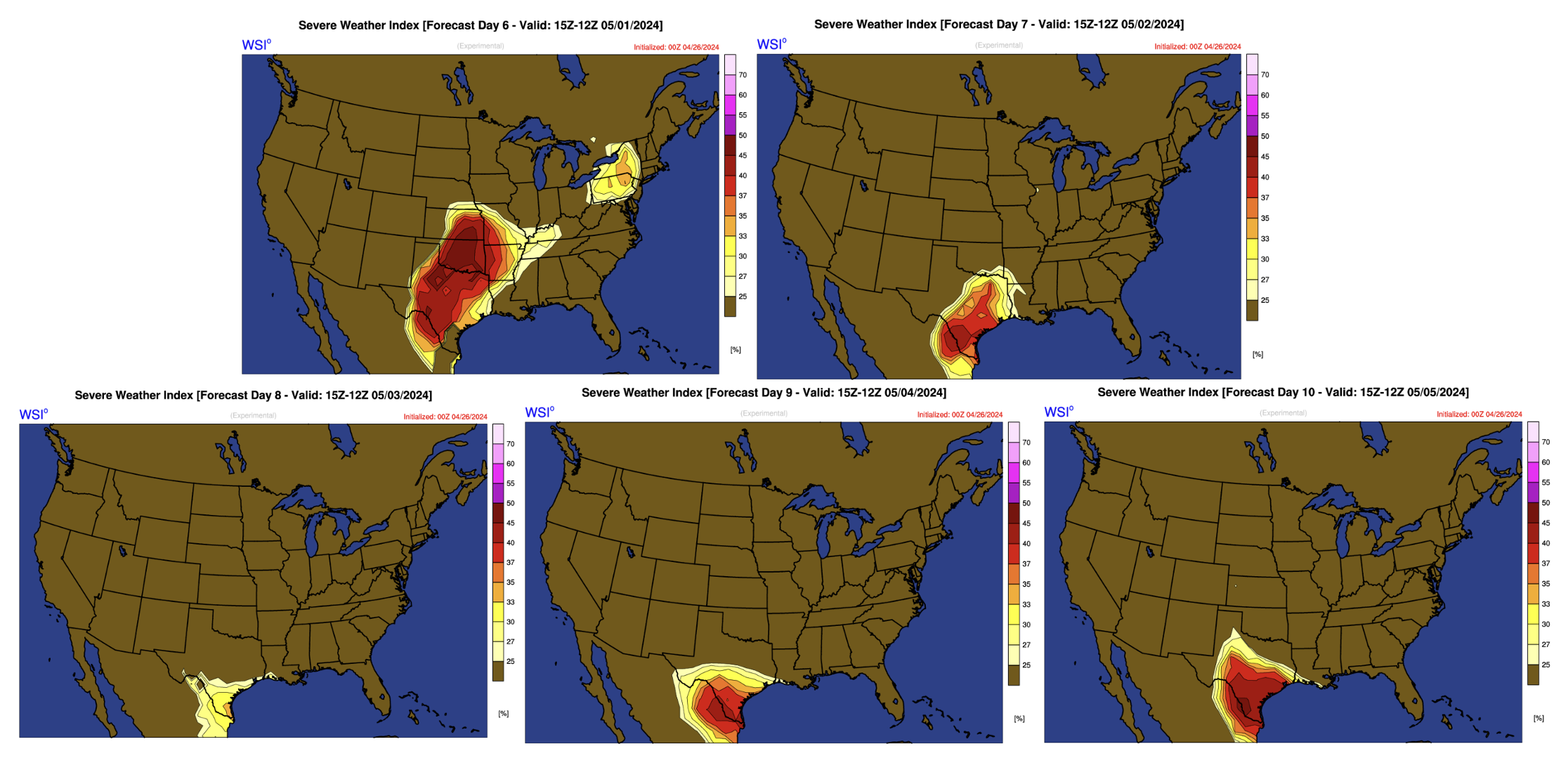
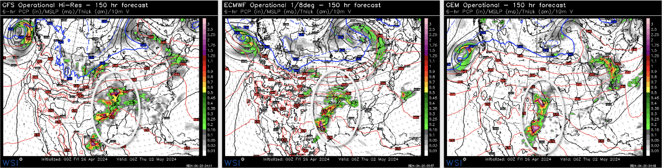
The energy moving into the western US will result in a few shortwaves traversing the Rockies, setting the stage for continued severe weather potential across the Plains and Midwest. Notably, current guidance suggests the coverage and duration will diminish next week, especially when compared to what is expected in the 1-5 day period. However, the 0z operational Euro highlights a few rounds of potentially severe weather across the Southern Plains and Lower Mississippi Valley on Wednesday and Thursday, with another dynamic low pressure system moving through the Northern Plains next Sunday resulting in another chance for widespread severe across the Plains and Midwest. Naturally, predicting the exact timing of storms and their associated frontal boundaries presents a noteworthy challenge, with a significant margin for error in the forecast at the regional scale.
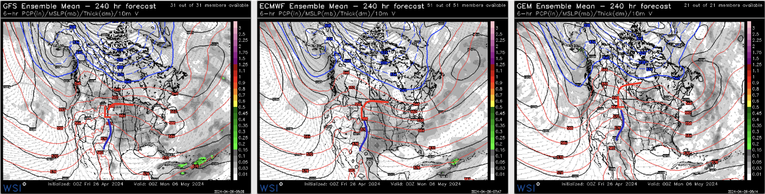
The period will start with a weak, upper-level low drifting into the Northern Plains, with rain, scattered showers, and thunderstorms. A long, trailing cold front will be draped across portions of the Mississippi Valley and Southern Plains, supporting increased chances for thunderstorms, with the potential for some severe weather. Once this system departs the region severe weather chances look to decrease briefly due to a deep trough moving into the Pac-NW, acting to reinforce and expand a potent ridge across the Mid-Con. However even with the expanding ridge, there still is potential for a few more disturbances to roll off the Rockies into the Plains and Upper Midwest, sparking some additional thunderstorms and severe weather chances late in the period.
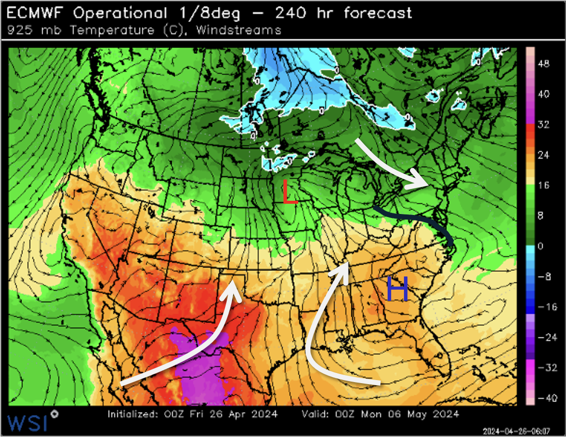
Notably, as the strong, mid-level ridge axis shifts west late next week the Northeast will see greater chances of cold frontal passages and changeable temperatures. The low pressure system over the Northern Plains is expected to move into eastern Canada, with the associated cold front beginning to traverse across the eastern US late next week. This will result in brief periods of rain, showers, and occasional thunderstorms, with southerly flow ahead of the front supporting well above-average springtime warmth, especially across the Southeast. Following the system’s departure, much cooler air will filter into the Northeast by the end of the period, bringing a brief stint of below normal temperatures to the region.
Degree Day and Model Weighted Forecast Overview:
The -PNA/+WPO pattern will lead to persistent warmth across the central and eastern US, significantly reducing the late-season HDDs below the seasonal average. However, CDDs are expected to see a slight increase, with above average heat and humidity across the Southern Plains and Southeast boosting CDDs above normal. There is a general cooler risk, perhaps favoring the northwestern US, based on the latest ensemble models and -PNA correlations.
GWHDDs: The period average GWHDD value is down to 36.8. The GFS op has 35.3, the GFS ensemble has 21.3, the ECMWF Op has 24.9, the ECMWF ensemble has 25.1, the GEM op has 27.7, and the GEM ensemble has 21.1. The morning AG2 forecast is for 22.
PWCDDs: The period average PWCDD value is only up to 12.5. The GFS op has 14.5, the GFS ensemble has 16.7, the ECMWF Op has 17.3, the ECMWF ensemble has 15.5, the GEM op has 15.8, and the GEM ensemble has 17. The morning AG2 forecast is for 17.1.
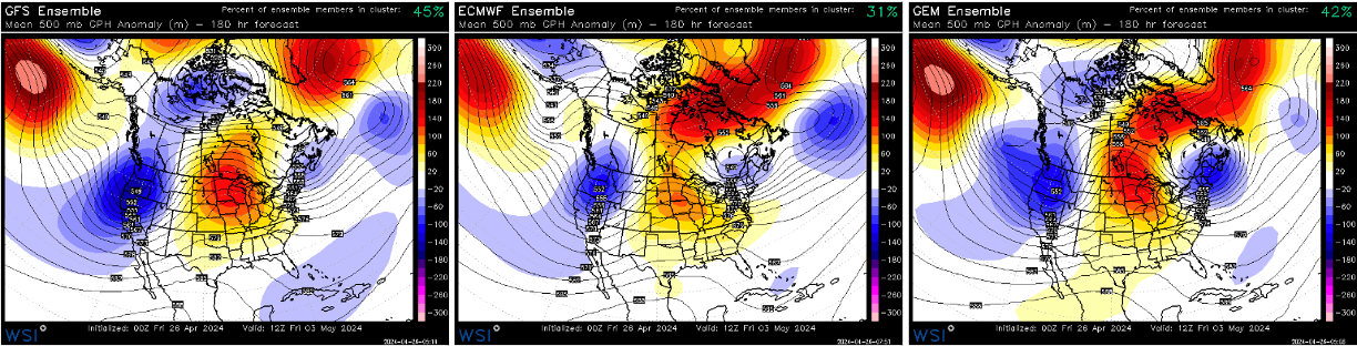
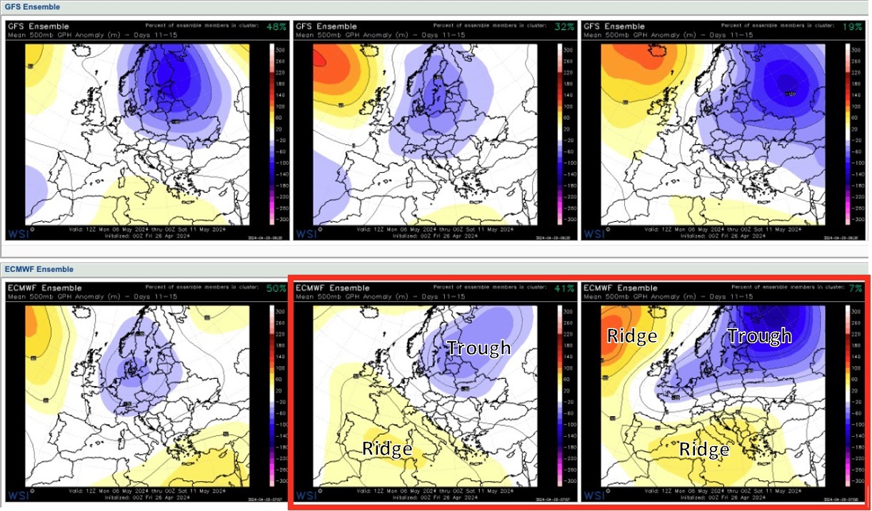
To end this week, the 00z ECMWF ENS came in with lower clusters resolving higher heights across the southwest and south through days 11-15, as can be seen below.
ECMWF cluster 2 in particular, which contains 41% of the members, shows an arising, interesting risk of warmer conditions developing across the southwest under stronger ridging, lifting the otherwise cooler further northeast. Compared to the rest of the clusters, interesting enough, that specific cluster does not show the anomalous high pressure system south of Greenland/Iceland.
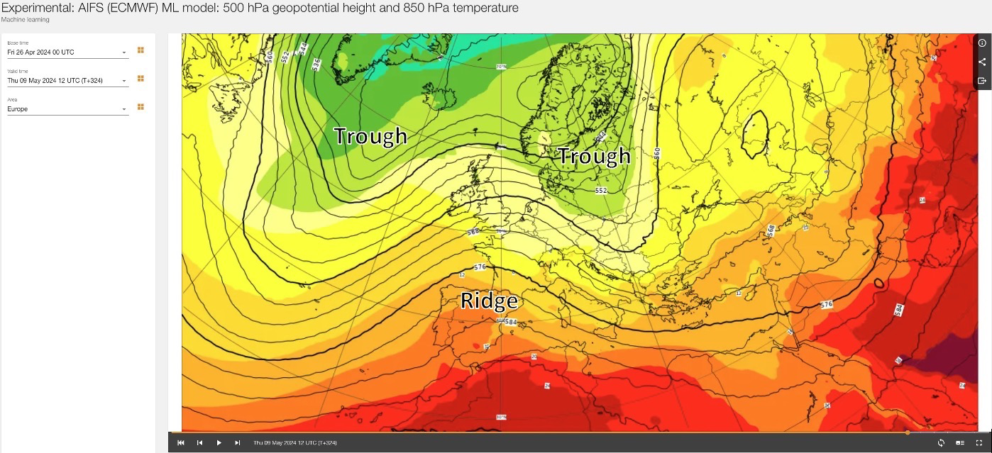
The ECMWF AI model seems to support its second ensemble cluster into week 19, resolving ridging building across SW-W Europe, with troughing south of Greenland/Iceland and across northeastern Europe, as per the chart below valid 12z Thu May 9.
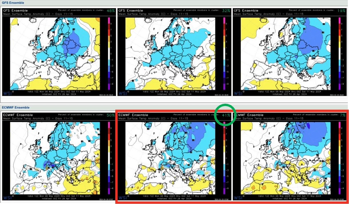
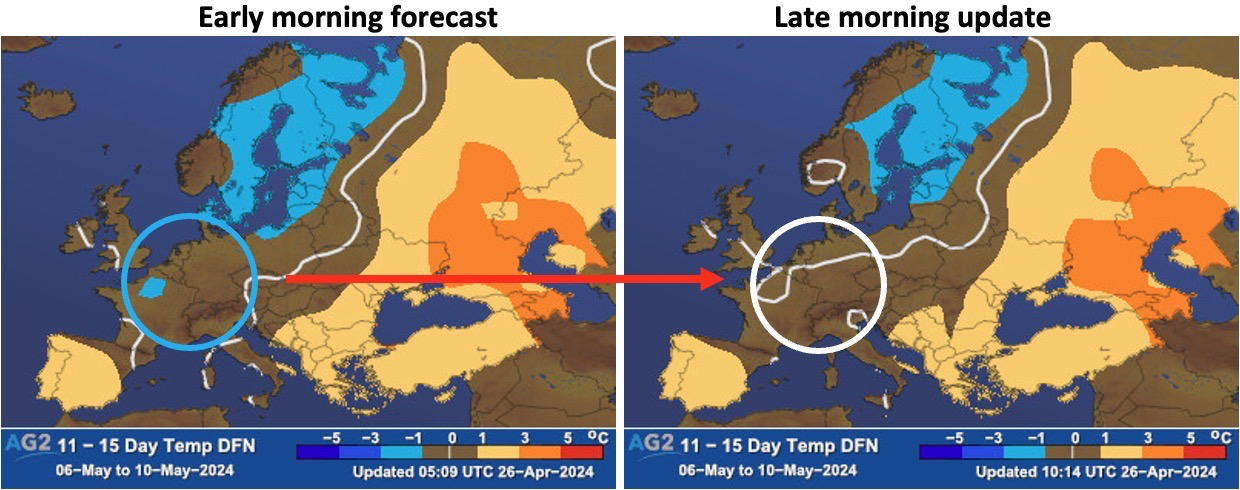
Our forecast update, including the 00z model runs, picked up on those risks by warming up a bit across central areas of Europe, compared to earlier this morning.
Bottom line: The 00z ECMWF guidance, especially per its 2nd ENS cluster (41%) and AIFS model, shows risks of higher pressure building through SW Europe into week 19, which would push cooler troughing further NE. This scenario also sees lower heights S of Greenland/Iceland vs GFS and top EC ENS cluster (50%). Our late morning forecast update also picked up on this risk moving warmer/less cool across central areas of Europe through week 19.
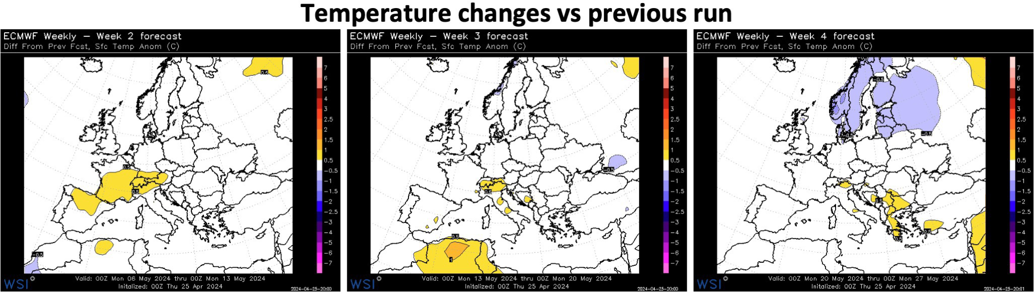
The plots below show the temperature changes in the latest run vs yesterday’s run for calendar week 19 (May 6th – 12th), calendar week 20 (May 13th – 19th) and calendar week 21 (May 20th – 26th). Warmer moves across norther Iberia through Alps week 19, then a few warmer specks southward week 20. Warmer moves towards the southeast, while cooler northeast week 21.
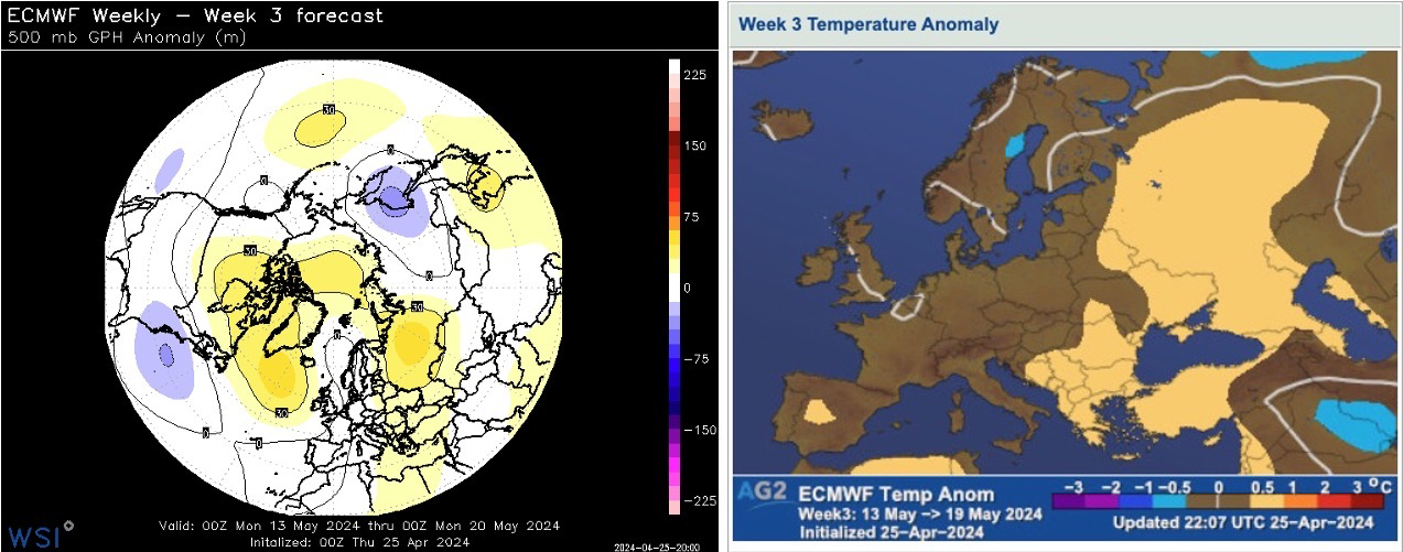
The hemispheric 500hPa geopotential height anomalies and the corresponding temperature anomalies for calendar week 20 are shown below. A -NAO type pattern is resolved with higher heights just south of Greenland and Iceland, with slack troughing across the southwest through Nordic regions. Higher pressure also towards western Russia into the southeast. The resulting temperature anomalies lie on the warmer side for mainland Europe, especially SE, while nearer neutral across the British Isles and Scandinavia.
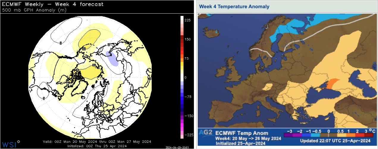
Into calendar week 21, lower pressure northwest and higher pressure southeast result in generally warmer anomalies, still stronger southeast, with nearer seasonal temperatures towards Scandinavia, leaning cooler far north.
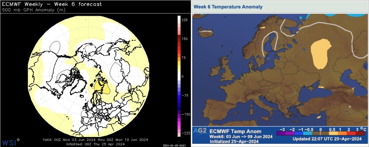
Moving into calendar weeks 22 (May 27th – June 2nd) and 23 (June 3rd – 9th). Very weak patterns continue to arise towards these later EC weekly forecast weeks, forcing confidence on the lower end. Slightly ridging can be found across Europe week 22 in the ensemble mean averaging out fairly different scenarios. Slight ridging northwest and slight troughing southwest arise in week 23 forecast. Weak warm anomalies result from such washed-out patterns, away from nearer neutral anomalies towards the northeast, or even east for a time week 22.
Now onto renewables and comparing through the weeks.
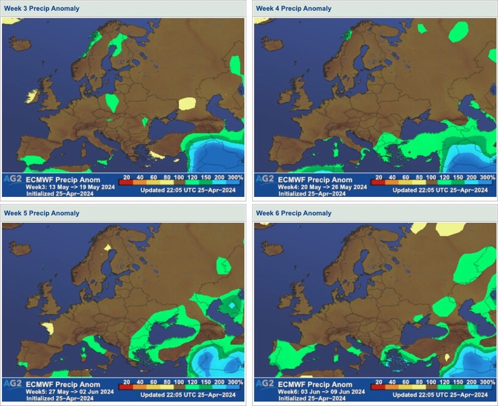
The precipitation anomalies through calendar weeks 20 to 23 are shown below. Slight signals of drier are resolved northwest, while otherwise nearer normal, or slightly wetter towards the south and southeast. We pose though lower confidence on this again, given the larger model spread.
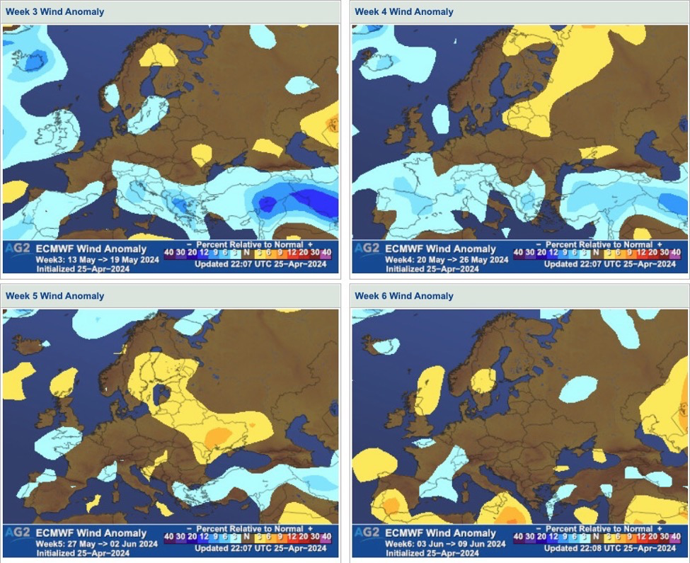
With regards to winds, near to below normal levels are forecast for most regions mid-late May, before slightly higher winds may return later on, but with low confidence.
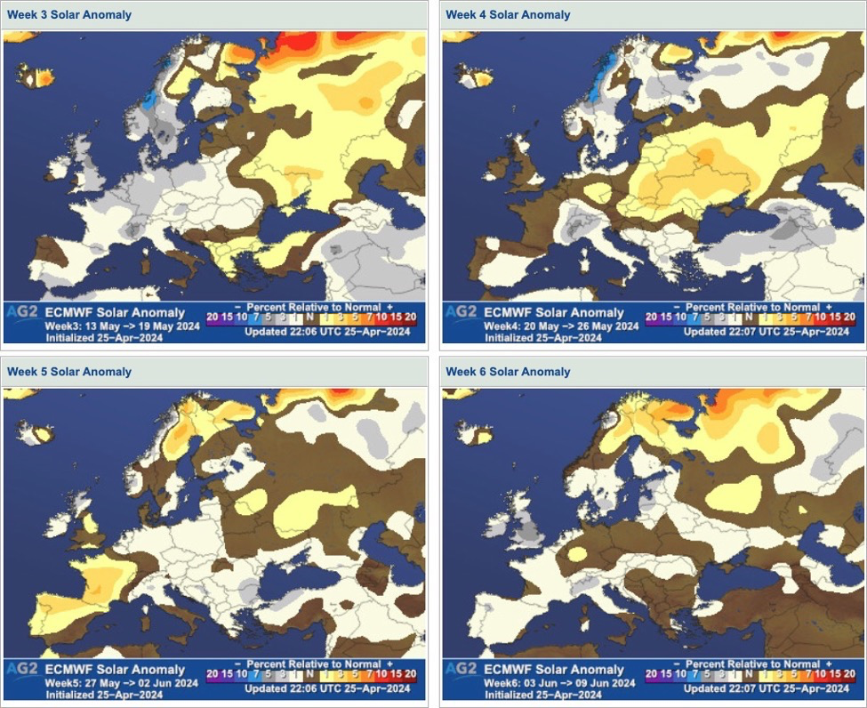
Finally onto solar, near to below normal solar seems to prevail throughout the period, with very volatile brighter spells resolved southeast week 20, east week 21, and southwest week 22.
Bottom line: The latest ECMWF weekly run for Europe shows nearer normal temperatures overall N, with warmer anomalies S throughout the sub-seasonal timeframe. While we like that as a general picture, we do however have to consider increasingly low confidence, especially towards June, where patterns are very week for Europe. A few spells in and out of warm/less warm weather remain likely through May and possibly into early June, with the NAO tending negative. As for renewables, overall drier NW, wetter S-SE, leaning calmer mid-late May, a bit breezier into June, with solar a tad on the lower end as a whole, but with lower confidence.
Posted inEurope Medium Range, European Sub-Seasonal|Comments Off on Europe: Latest ECMWF weekly – cooler N, warmer S mid-May through early June, but confidence does not shine.